
Geography of Nepal for Loksewa: Facts the Exam Asks
The geography facts that score in Kharidar and Nayab Subba: Nepal's position and extent, the three physical regions, river systems, mountains and lakes, provinces and districts, protected areas, and a study method that works.
The geography of Nepal loksewa unit is where disciplined candidates collect easy marks: the facts are fixed, the question styles repeat, and a dozen tables cover almost everything. Kharidar's first paper draws six GK questions from the solar system and geography unit; Nasu's first paper asks four questions directly from Nepal's geography, and the Nasu second paper has a whole section on the country's geographic, social and economic situation.
Position and extent
Nepal lies between 26°22' and 30°27' north latitude and 80°04' and 88°12' east longitude, bordered by China to the north and India to the east, south and west. Average east-west length is about 885 km, north-south width varies roughly between 145 and 241 km (mean about 193 km), and the total area is 147,516 km². These exact numbers appear in MCQs verbatim — learn them as written.
Three physical regions
From north to south: the Himalayan region (high mountains, glaciers and glacial lakes, thin population), the Hilly region (the Mahabharat range and the valleys between, where most towns sit) and the Terai (the flat, fertile strip south of the Chure/Siwalik hills). Questions pair each region with its share of area and population, so keep a three-column note.
River systems
Nepal's three great snow-fed systems are the Koshi in the east, the Gandaki in the centre and the Karnali in the west, with the Mahakali on the western border. Second-grade rivers such as the Bagmati, the West Rapti and the Kamala rise in the Mahabharat; third-grade rivers rise in the Chure and swell only in monsoon. "Which river belongs to which system" and "longest/deepest" items are standard: the Karnali is the longest river inside Nepal and the Kali Gandaki cuts the deepest gorge.
Mountains and lakes
Of the world's fourteen 8,000-metre peaks, eight stand wholly or partly in Nepal, Everest (8,848.86 m) first among them. Pair each peak with its range, and each famous lake with its district: Rara (Mugu, the largest), Shey Phoksundo (Dolpa, the deepest), Tilicho (Manang, among the highest), Phewa (Kaski), Gosainkunda (Rasuwa).
Provinces and districts
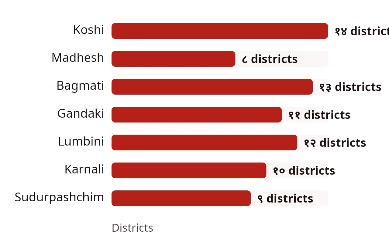
Nepal has 7 provinces, 77 districts and 753 local levels (6 metropolitan cities, 11 sub-metropolitan cities, 276 municipalities and 460 rural municipalities). Koshi has the most districts (14), Madhesh the fewest (8). Learn each province's capital and its largest and smallest districts — these are Level II matching questions.
Wetlands and protected areas
Nepal's protected-area network covers national parks, wildlife reserves, hunting reserve and conservation areas, roughly a quarter of the country. Chitwan (the first national park, 1973) and Sagarmatha are world heritage sites; the Ramsar list of wetlands, starting with the Koshi Tappu area, is a recurring question. Keep a one-line table: site, district, year.
How to study geography
- Build the tables above into one notebook spread each.
- Say the numbers aloud: coordinates, area, counts.
- Drill weekly MCQs: the free practice sets include geography, and the AI practice in the Dipa App keeps re-serving your wrong answers.
- In the final week, revise only the tables, not prose.
World geography too
The Kharidar unit also touches the solar system and world geography: planets in order, continents and oceans by size, and famous lines (the equator, the international date line). Three or four one-line facts cover most of what is asked.
For the written-paper angle, continue with the Nasu second paper guide; for the overall plan, how to prepare for Lok Sewa.
Frequently asked questions
Between which latitudes and longitudes does Nepal lie?
Between 26°22' and 30°27' north latitude and 80°04' and 88°12' east longitude, with an average east-west length of 885 km.
Which provinces have the most and the fewest districts?
Koshi Province has the most with 14 districts; Madhesh Province has the fewest with 8. Nepal has 77 districts in all.
How many geography questions come in the Nasu first paper?
Four questions come directly from the geography of Nepal sub-unit, and geography also supports the second paper's section on Nepal's geographic, social and economic situation.
Sources
- Kharidar or equivalent syllabus: solar system and geography (PDF, Nepali), Public Service Commission (2024-07-25)
- Nayab Subba or equivalent syllabus: geography of Nepal (PDF, Nepali), Public Service Commission (2024-07-25)
Courses for this topic
Kharidar General Knowledge (GK): Paper I
The 60-mark GK part of the Kharidar first paper: all five units with video, notes and MCQ practice.
Nayab Subba General Knowledge (GK): Paper I
The 60-mark GK part of the Nasu first paper, with video, notes and MCQ practice.
Nayab Subba Second Paper: Contemporary Studies and Public Service Management
The 100-mark Nasu second paper: geography and economy, the constitution and federalism, and public service, with answer…

Study in the Dipa App
Buy courses, join Live Classes and practise every day in the app. Payment works inside the app with eSewa.

Author
Dipa Academy editorial team
Dipa Academy's editorial team writes Lok Sewa guides from the Public Service Commission's official syllabus, notices and results, and cites every source.
Read next
History of Nepal for Loksewa: the Dates That Score
21 November 2026 (मंसिर ५, २०८३)Current Affairs for Loksewa: a 20-Minute Daily Method
21 November 2026 (मंसिर ५, २०८३)Constitution of Nepal for Loksewa: Parts, Articles, Facts
21 November 2026 (मंसिर ५, २०८३)